
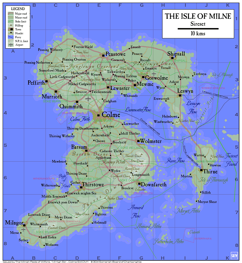
The Isle of Milne is situated off the northwest coast of Somery, in the shire of Sireset. Together with the isle of Thirnseigh and a great number of other small islands it forms the hundred of Milne, its seat being Colme, its largest town. The main island covers ca 1,027 sq. kms, stretching ca 44 kms from east to west, and ca 53 kms from north to south. The island is one of the most popular tourist destinations in Somery, but in spite of the invasion of visitors during the summer season the island seems to be able to swallow them all, and it's not unheard of to find plenty of spots unspoilt by tourists, and maybe even a small beach all to oneself.
The island is almost divided in two with only an isthmus, covered by the town of Colme, connecting them. The southern part, Thorse, has some lowlands, Barsum Deane, to the west but is mostly dominated by the hilly area of Thorse Downs to the south and southwest. Thorse also has the island's largest woodland area, Rownop Wode. The northern part, Penglewyn, is considerably lower with a few hills, The Overland, to the west and an open plain, The Emnet, to the east. The north is more densely populated and most of the area is cultivated, while the south has quite a few moors and woods which may appeal to outdoor people.
There are nine NPAs (Nationally Protected Areas, with protective restrictions for visitors) worth attention on the island, among them the caves of Stancleves, the forest of Rownop Wode and Thorse Peaks. Below is a list of them and other places that may be worth a visit.
Barsum (D 5). While most towns on the island has a weekly market, none of them is as famous as that of Barsum. During the Michelfair week in late September it grows to be by far the most popular on the island and the Turrow Market, a gem in itself surrounded by old merchant houses, is crowded with people from all around. Contrary to most markets the greater part of the goods offered is not a lot of junk, and it's not unlikely to make a find or two, particularly at the flea market in the Town Hall annex.
Colme (E 4) is without competition the largest town on the island, with a population of 20,000, and is consequently its commercial and administrative centre. Here is where most tourists arrive, by ferry or by air. The town is quite old and has an almost intact town wall, and a noticeably regular street pattern which some would like to date back to before the arrival of the Summer clan. The name is popularly believed to mean 'stone circle' (Es. 'cylch mean'), referring to the ancient stone circle in Culmean Green to the north of the town centre. Not far outside the town, to the northwest, you find Craxholme Goar NPA.
Craxholme Goar NPA (C-D 4) just outside Colme is a popular place to go for the Colmers in their free time. The peninsula of Craxholme Goar is a combination of grasslands and cliffs ending in wetlands to the west, with plenty of birdwatching opportunities. Certain areas are further restricted during breeding season, late spring - early summer.
Downfareth (G 6) is best known for being near the Stancleves caves but holds a quaint small town charm of its own that is well worth discovering. Across the firth with a great view of the town lies Erlscather, a hill that is a well known landmark. Tales are told about the Erlqueen who, sitting on the hilltop, tries to lure sailors with her sweet song to run aground .
Ernewick neighm Sea (C 6) is the natural centre of the Bight of Sands area, which boasts some of the best beaches on the island. All along the seaside there is a great number of guesthouses to meet the invasion of guests in the summer. You can also find apartments to rent, with great views of the sea. If you are tired of basking in the sun and splashing in the waves you can always make a trip to Withersands NPA and enjoy the birdlife.
Fixen Howe NPA (D 2). While the Penglewyn Overland mostly descends slowly northwards, Fixen Howe is a dramatic exception. It is like part of the slope has forgotten to continue downwards and then suddenly remebered. To the south the hill is gently rising to its summit while to the north it drops dramatically which offers a splendid view of the lower lands surrounding Foxton Hield to the north and the sea in the distance. It probably has gotten its name from the fact that foxes (fixen=female fox) are quite common in the area.
Goswolme (G 3) is the island's second town in size. Its most famous sight is the stationary tall ship Eithmarow in the harbour which serves as a hotel and youth hostel. It also has a popular marina, and is the start and finish of the Cullamellin Cup, which is among the most prestigious of sailing competitions in the country, claimed to be the oldest still held.
Mewme (G 3) is among those little towns whose population take pride in making their town centre green and blooming. As you walk along the streets you will find garden upon well tended garden, and late July people gather in the Town Eddish for the annual floral festival to enjoy each others efforts and maybe find somethings to add to their own green spot. The festival usually attracts a lot of people.
Milngor (A-B 7) is almost as far west as you can get in Somery, and, according to legend, this is where the Summer clan first went ashore. There is a monument in stone in the harbour commemorating this event. The plaque on the monument is engraved with the phrase "Into the Summer lands" in both Somerish ("In to tho someres land") and Classic Estron ("I mewn i'n tiroedd hafaidd").
Outerith NPA (I 8), a small islet about 500 m wide and 800 m long, situated about 5 km to the east of Sutherholm Aiths, is the breeding ground for thousands of various seabirds, like seagulls, cormorants and puffins. There is a regular boat service from Meryot Sheat during the summer season, but visiting the island is further restricted during breeding season, late spring - early summer. Getting ashore can be complicated in rough weather since there is no natural harbour.
Rownop Wode NPA (E-F 5-6) is an area of partly quite dense deciduous woodlands, put aside to be protected, containing oak, ash, hornbeam, hazel and hawthorn. A group of particularly old oaktrees are worthy of attention.
South Thorse Downs NPA (B-E 7-8)
Stancleves NPA (F-G 6-7) is one of the few cave systems in the country that are at least partly accessible to the general public. Myths have it that it's the home of the Erlfolk, and when man appeared and discovered the caves they just moved farther into the caves. If someone by chance would find the secret passage to the inner caves they are, according to legend, certain never to be seen in this world again.
Sutherholm Aiths (H 8) have regular boat services from Downfareth, and also Meryot Sheat.
Thirne (J 6)
Thirstowe (D 6) is the biggest town of Thorse, and the island's third in size.
Thorse Peaks NPA (F-G 5-6)
Withersands NPA (C 6)
Wynnest Aiths NPA (I-J 3-4)
The Milnish Rede of Wilfore
14, High Str.
COLME
SI4 CM1
Tel. 091-77 76 75
kithing@mrw.co.sm
|
|
|
|